Showing posts with label travel. Show all posts

2 Feb 2018

Exploring Haida Gwaii

Sci/Why's peripatetic correspondent Margriet Ruurs sends us another report from a fascinating part of the world - this time from Haida Gwaii, on the western edge of Canada. -CE

By Margriet Ruurs

Haida Gwaii – the very name conjures up images of windblown spruce clinging to rocks surrounded by foamy waves, not unlike an Emily Carr painting. The archipelago stretches along the northern BC coast almost to Alaska. You can reach it by ferry from Prince Rupert or fly in from Vancouver.

We flew into Sandspit, a tiny town on the northeast shore of huge Moresby Island. We wanted to visit the very southern tip, which is in a National Park called Gwaii Haanas. Basically, the only way to reach this remote region is by a Zodiac (inflatable boat) tour offered by a local wilderness company called Moresby Explorers. We studied our options, counted our coins and decided to splurge on a four-day trip with a photography theme.

Bryan, our guide and skipper, picked us up and also five other guests with whom we would spend the next four days on a Zodiac. We drove from Sandspit across a ridge of Moresby Island, on dirt logging roads, to Moresby Landing where we were outfitted with bibbed rain pants, large rain jackets and gumboots. We’d live in these for the next few days. We wore undershirts, a sweater, a fleece jacket topped by our own rain jackets and then the provided rain gear over top. This meant we could only wobble like astronauts in space suits.

Of course we had prepared ourselves for four days of driving rain, grey skies and grey waves. Fortunately, we were lucky and only ended up with a half day of rain and three-and-a-half days of blue sky and sun and/or cloudy but dry weather. Considering that Gwaii Haanas averages rain for about 230 days a year, we were lucky.


We had not even left the Landing when I spotted the first black bear browsing on the intertidal beach. The island’s bears have evolved to have much longer snouts than the mountain bears we are used to seeing on the mainland. Like the Galapagos, even the same species of animals have made adaptations to different local environments resulting in, among others, a different subspecies of stickleback fish in every lake. At least 39 distinct subspecies of plants and animals evolved in the archipelago, including seven mammals, three birds and fifteen species of the stickleback fish that are found nowhere else in the world.

We cruised across inlets and around Louise Island to spend the first night at Moresby Float Camp, a guest house anchored in a secluded fjord. The blue skies reflected in mirror-calm green waters. We docked and were welcomed by two young women who cooked for us, offering us tasty appetizers, tea, coffee and hot chocolate. They even had a fireplace, giving us much needed warmth to warm our chilled hands and feet. After a great dinner of bbq salmon, salad, veggies and rice we fell asleep in no time.

The next morning we bundled up again. This became a ritual: two or three layers of warm clothes, thick socks and gloves. Then our own outer gear, the provided rain pants tucked into the gumboots and the rainjacket over top of everything else. By the time you can’t bend down anymore, you still have to manoeuvre into a lifejacket and into the waiting Zodiac. We’d pull a warm hat and scarf over nose, mouth and face and then we were ready to zoom across Hecate Strait to our next destination.

On our way by Zodiac to the most southern tip of Gwaii Haanas, we visited ancient village sites and remnants of totem poles in several locations: Skedans, Tanu, S’qang Gwaii, Rose Harbour and more. Each site has its own intrigue and charm. Skedans is a village site with house remnants and totem poles, but not as many as in the most southern tip S’qang Gwaii. Here, a mystical and misty atmosphere enhances the site where old spirits dwell and history is tangible. The bleached and weathered totems lean against moss covered house beams. The beach still tells stories of canoe runs between rocks, where the “Vikings of the Pacific” showed their power by rowing their long boats far east, north and south, taking slaves as they encountered other nations.

I was intrigued to learn that a Haida Chief could marry a slave woman, thus making the former slave the most powerful matriarch of the clan. In this matriarchal society, men do as the leading woman dictates and children are part of their mother’s lineage.

I also learned about different totem poles: the shortest one were usually house poles, depicting the family’s clan and history. Tall plain poles with rings are potlatch poles, showing how many potlatches, or celebrations, have been held. Some poles are a memorial for a particular person, sharing his life story, while yet others have a hollowed-out square opening at the top housing a bentwood box of bones: a burial pole. Their silent stories are impressive and pay tribute to a society that lived here long before “contact” – as the period after the arrival of European explorers’ ships is called.

Houses were large, sometimes dug down to allow more space. Immense ceiling beams were held up by corner posts and closed by cedar walls. Now, all that remains is rounded beams covered in soft green moss, often with a new cedar tree growing on each corner as the trees reseeded. Slowly and silently, history is swallowed up by the rainforest. The Haida people have chosen to let their history return to the earth, as it always has, rather than have Parks Canada follow their usual mandate of preserving history.

We were most impressed by the Watchmen. This ancient term refers to Haida who spend the summer in each historic location. They are provided with a small house with a wood stove and basic comforts. Here they work for the summer, hosting visitors. They are extremely well spoken, gracious hosts with a wealth of knowledge about their people. Each host told us amazing stories. Haida Gwaii is made up of stories and the oral history seems alive and well. We heard stories of how people first came to populate the earth when Raven found a clamshell full of little people on Rose Spit. He pried open the shell and the people spilled out. Raven also brought light to the world.

Bear married a woman who gave birth to bear cubs, and in return he gave hunting powers to humans. There are many tales of supernatural beings in this land. Mostly, these are people wearing animal cloaks. Eagle, Raven, Whale, Bear – they all have specific powers and fascinating stories. Haida also strongly believe in reincarnation.

One of the men who told stories, told us of the impressive oral history. “When I was about 10 years old,” he said, “my uncle called me into his house and told me a two-hour story. The next night I had to come back and tell the story back to him without embellishing, best as I could.”

This repeated night after night until he had memorized much of his own history. The tradition continues today as he tells his daughter the ancient tales and makes her tell them back to him.

We learned to chew spruce tips and licorice root. Even ate herring roe on kelp. We saw many, many eagles. A few glimpses of whales as well as two bears.

One overnight was spent in Rose Harbour, an old whaling station. Much debris, buildings and rusty tools remind one of an era when people caught and processed whales for oil. I found it a sad place to be. The lone woman who lives here offers a guest house and meals to Moresby Explorers. We ate greens from her immense garden and freshly caught ling cod. In the morning she ground grains on her converted exercise bike to make us pancakes with rhubarb sauce from the garden. An outhouse and wood-heated shower made it into a rustic adventure.

All photos by Margriet and Kees Ruurs.

22 Sept 2017

Moving Moai and the Birdman Battle

By Margriet Ruurs

Note: This is the second of two posts by Margriet about Rapa Nui. To see the first, go to https://sci-why.blogspot.ca/2017/09/exploring-world-through-travel-rapa.html

Walking along the steep cliffs of the southwest coast of Rapa Nui, or Easter Island, I gaze down on foaming white waves pounding the shore of a small island: Moto Nui. This is where history was made.

The view of Moto Nui from the cliffs of the larger island, Rapa Nui.
The first inhabitants likely arrived on Rapa Nui in wooden canoes from far-away Tahiti. From these first few grew a population of thousands. But European diseases and fighting reduced their numbers to a low of 110 at one point. After the era of the moai (stone figure) carving culture, competing tribes designed a non-violent way to establish order on Easter Island: the Birdman Cult. Chosen young men competed for the right to have their tribe rule for the next year, until the next competition was held.

Birdman figure
The competition was held near the most important site on the island, the Rano Kau volcano, and consisted of climbing down the steep rock face of Orongo to the wild ocean below, building rafts from reeds, using these as flotation devices and swimming the rough kilometre-wide passage of pounding ocean to Moto Nui island.

The young men had to bring back the first egg laid by birds returning in spring. They tucked this egg into a woven headband, swam the ocean and climbed the cliff to hand the egg, unbroken, to the chief.

I saw tiny rock houses at Orongo and scattered rocks carved with birdman and boat pictures. We climbed the sides of the ancient volcano to look inside the crater, filled with shallow lakes where drinking water was collected and reeds for the rafts were cut.

The best came last, when we visited the site famous from so many photos – the long row of moai standing shoulder to shoulder. This is iconic face of Easter Island.


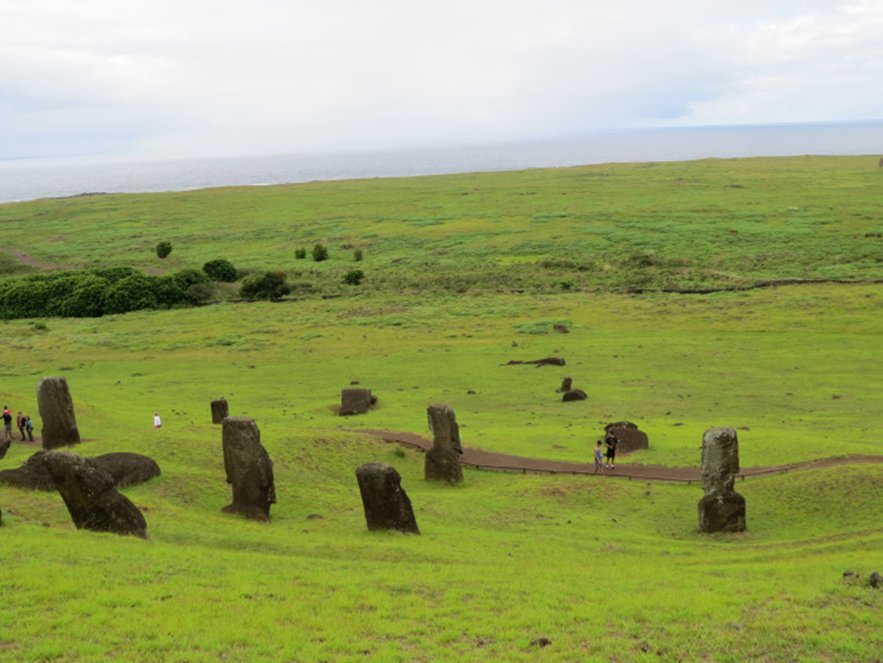
But my favourite site is the quarry. When I first heard the name, I pictured a rock excavation site where rocks were dug up. However, when you approach the quarry, it is as if the stone people have come to life and are walking out of the mountain from where they were born. A gently sloping green side of a volcano is scattered with upright figures. They seem to be walking down, stumbling and standing all over the slopes. The sight gave me goosebumps and a lump in my throat.

The moai were carved here from gigantic blocks of basalt and lava. Weighing many tons and measuring up to ten metres in height, their individual features were carved. I had heard that most figures only show the upper body while the lower half is still buried.

Before I saw them, I thought that this meant that the moai had been covered by drifting sand over the ages. But that is not true at all. There is no sand. Only lava and rocks. The artists did not have ladders, so they dug deep pits in which they lowered or raised the moai until they could reach their faces to carve them.

Once a figure was finished, it was erected and “walked” down the mountain to spots all over the island – a mind-boggling feat that National Geographic has tried to recreate.

Why did people stop carving and moving the figures? It seems like they were in the middle of ongoing projects when work came to a halt. No one knows why.

Why did the Rapa Nui create these statues in the first place? Scientists believe that well-to-do families ordered a moai in memory of an important member of the community. When this person died, male or female, a moai was constructed in his or her image and erected over their bones.

Once the grey basalt figure, with or without red lava topknot, had been given white coral eyes with a black obsidian center, it was believed that the deceased person’s spirit had entered the moai and would now protect Rapa Nui and its future generations.


For details on Easter Island and its history, click here: http://www.mysteriousplaces.com/easter_island/

See a reenactment of ‘walking’ the statues here: https://www.youtube.com/watch?v=yvvES47OdmY

All photos by Margriet and Kies Ruurs. For more of the Ruurs's travel adventures, visit their blog, Globetrotting Grandparents.

15 Sept 2017

Exploring the World Through Travel: Rapa Nui’s Moai

By Margriet Ruurs

I was lucky enough to take a trip to Easter Island, Chile, earlier this year. I had booked a flight from Santiago. Before getting there I imagined an old, small airplane. I don’t know why – but I had thought it would be a local airline with an old prop plane. The opposite turned out to be true: Latam is part of One World and operates a brand new Boeing 787 on the route to remote Easter Island across the south Pacific Ocean. Only during the long flight does it become clear how distant this place is. From mainland Chile you fly at a speed of 850 km an hour for about 5 hours! The island is almost halfway between mainland Chile and New Zealand.

Rapa Nui from the air.
We arrived in comfort. But now imagine that you are an early explorer, sailing the Pacific Ocean in search of new lands. After weeks of nothing but water, you spot land. A green island with round, cone-shaped hills and the odd ragged cliff dropping off into the roaring ocean. As this Dutch ship, under the command of Captain Roggeveen, cautiously approaches the island, furling the sails that billowed from its three tall masts, you spot people. Giants.

Huge, towering people standing shoulder to shoulder with their backs to the sea. These stone giants are most likely meant to honour chiefs and other important people. For more than a thousand years – no one knows their exact date – they have been standing here, silently. Only a few statues face out over the sea, looking in the direction of other Polynesian islands, possibly the Marquesa Islands from where the first inhabitants of Easter Island might have come by canoe.

Roggeveen did go on land and communicate with the native population. As it happened to be Easter for the European Christian sailors, they named the island Easter Island: Paas Eiland in Dutch, or Isla de Pascua in Spanish. Never mind that the island already had inhabitants and a name: Rapa Nui. Like other islands claimed by European nations, it has now gone back to using and being proud of its original name and so I shall refer to Easter Island as Rapa Nui here. Since 1965 the island has been under Chilean governance. It uses Chilean pesos but has its own Rapa Nui postage stamps.

The stone statues, for which the island is famous, are so shrouded in mystery that it is hard to realize that they stand on a normal island where regular people live in a regular town. I had only ever seen images of statues and green grass and found it slightly jarring to arrive in this mysterious place to see ordinary trucks, cola machines, dogs – just like in any other town. Where was the mystery?

We walked across the tarmac to the palm-frond-covered entrance of a tiny airport. Each and every new arrival is greeted with a lei of fresh flowers.  People here still speak Spanish but also Rapa Nui, which is very Polynesian and looks like Hawaiian to us.

Rapa Nui is roughly the same size as Canada’s Salt Spring Island with almost the same number of people, around 7000 – increasing with tourists. They also face similar problems, such as sustainability, water shortages and recycling. Of course this island is much further away from a mainland. Supplies used to come, and still may, once a year by ship. Everything else is flown in. So the cost of a soft drink or anything else is sky high. A small bottle of water, which was 1 dollar in Santiago, costs 3 dollars here. Everything needs to be recycled or re-used. A sign in our bathroom asked us not to "throw paper at the toilet" – which we took to mean no flushing of paper.


Our very first moai, or stone statues, was a row of five that, unlike all other moai, face out over the ocean rather than inland with their backs to the sea. Why? We can only guess and only “the ancestors” know the real answer. They sit near two platforms on which the moai typically rest. These platforms are built of huge square basalt blocks with straight lines and rounded corners. It is impressive how precisely these were constructed so many hundreds of years ago, without the use of metal tools.

Once the guide pointed it out, we noticed moai that have fallen forward, on their faces, and cracked. Many were destroyed during a civil war between the Long Ears and the Short Ears tribes around 1680, as well as by missionaries, neglect and the passing of time.

Top Knot lava stone
The standing, reconstructed moai are about 5 metres tall. Each face is quite individual. A few wear "top knots" – these round blocks of red lava have a smaller red part on top and are said to resemble not hats but hair, worn traditionally in a long ponytail tied in a knot on top of the head, just like most men here still wear it.
Typical modern men's "top knot" hair style on Rapa Nui
All photos by Margriet Ruurs. You can find more of Margriet's travel stories at Globetrotting Grandparents.


23 Oct 2015

Citizen Science: A Way To Become Involved

By Margriet Ruurs

Definition - noun cit·i·zen \ˈsi-tÉ™-zÉ™n also -sÉ™n\   \ˈsÄ«-É™n(t)s\
Citizen science (also known as crowd science, civic science or volunteer monitoring) is scientific research conducted, in whole or in part, by amateur or nonprofessional scientists.

Are you a citizen interested in science? Have you always had a secret wish to be a scientist, but instead you ended up being a bookkeeper, a manager, a writer? There is still hope! You can participate in, and contribute to, science projects around the globe. Making use of the internet, scientists have come to realize the enormous wealth of manpower available to science by using volunteers. You can be an amateur bird watcher and contribute to the knowledge of the American Ornithologist Union. Or you can help track anything from bees to killer whales. You can count moths or collect microbes in your own home - all as a “citizen scientist.”


When you check the list of possibilities, it is hard not to get excited about the contribution you can make to science by doing what you already enjoy doing, simply by signing up as a volunteer and making your actions count. Thanks to mobile phones, for instance, you can help to improve accuracy of magnetic navigation systems. Sounds impressive, right? All you need to do is download the app and send in your magnetic data.

You can turn your daily stroll along the shore into scientific research by listening for orcas and submitting your findings to The Whale Museum on Washington’s San Juan Island.

Being a volunteer scientist is not restricted to your regular daily life at home either. Tens of thousands of people in The Netherlands, for instance, contribute to the preservation of wildlife or natural areas by tagging butterflies, by constructing bee-houses or by planting trees. One website offers to pay all transportation and accommodation if you want to spend four days planting sea grass in the muddy tidal flats of northern Holland or Germany. You can also spend two weeks living in a lighthouse, in complete isolation and surrounded by the sea at high tide, counting seals and taking an inventory of sea birds. You just sign up as a volunteer caretaker for the Dutch National Nature Conservancy (Staatsbosbeheer).

If you’d rather go on night patrol on a Costa Rican beach, you can do so by joining a GoAbroad.com project to protect sea turtles. The Earthwatch Institute has also realized the enormous potential of using keen citizens to contribute to scientific research. They invite you to explore Nicaragua’s geology. You’ll be setting up high-tech scientific instruments in and around the Masaya’s crater. You’ll hike through the forest to record information on pollinating insects and to collect plant, water, and soil samples. You’ll be part of a field research team which may make this a more memorable holiday then simply lying on a beach. Of course, in a case like this, you’ll pay your own travel and accommodation.


Whether you use your daily stroll or dedicate your entire holiday to science, doing something meaningful for the environment will, no doubt, be a rewarding experience if you become a citizen scientist.

For previous Sci/Why columns on citizen science projects, just type "citizen science" into the Search box on the right side of this page.

All photos by Margriet Ruurs.

15 Apr 2014

Busy as a Beaver - and that's very busy!

A busy Yukon beaver. John Meikle photo.
Here's a short note and a link from Sci/Why blogger Margriet Ruurs, who has abandoned us all - temporarily - for the joys of travel.

Margriet says:

"Quick! Which animal is on the Canadian nickel? Now look at this amazing video for an intimate look at some busy beavers in Calgary."

You can catch up with Margriet and her travels (if you move quickly enough!) on her Globetrotting Grandparents blog.

17 Jan 2014

Stories in Slate: Touring an Underground Mine

Corris Mine Explorers tour, Wales
By Marie Powell (Photos by L. L. Melton)

A tour of an underground mine offered a hands-on science opportunity during a recent trip to the Braich Goch slate mine in North Wales.

We spent more than two hours in the mine tunnels with our expert guide Mark of Corris Mine Explorers. During that time, we explored the abandoned caverns, learned a little mining history, and examined original artifacts used in this once-prosperous slate mine.
Tallow candles in clay (L L Melton photo)

The underground tunnels date to 1836, and by 1878 the mine employed about 250 workers producing 7000 tons of slab and roofing slate. In its heyday, families negotiated for mining rights to the chambers, which were known as "bargains," Mark told us. Men and boys aged 10-35 worked the mine in near darkness, hoarding the tallow candles made from sheep fat that provided their only light source. They used clay to carry the candle with them and fix it to the slate walls of the mine as they worked


Tools (L L Melton photo)

We had a chance to see several original artifacts used in the mine and left there. These tools date back to the 1860s, Mark said. Using the mallet, a worker would strike the rod three times, then turn and strike three more, for a total of nine strikes. Black powder was packed into the hole. They used copper and brass rods because they don't spark, he added.
Mine shaft (L L Melton photo)

Since the mine is full of ledges and drops, and candles were scarce, it was important to have a reliable method of finding their way around the mine in almost total darkness, he said. They used a form of echo-location, orienting themselves to the sounds of dripping water in the cave, or to their own singing.

Tight fit


Most of the time we were able to walk upright, but at times there was barely enough room for a person to crouch. At one point Mark tied us to a rope and let us look out over a drop in the mine to a level below. Staring down at the eerily echoing caverns far below us, we were glad of our headlamps and gear, and hyper-aware of the danger the miners faced every day.
Mine artifacts (L L Melton photo)
Artifacts lined the mine at strategic locations. Mark pointed out the expected ones, such as a detonation box, explosives, and a "bugle" of black powder. Among the artifacts we saw a 19th Century example of recycling: a jar for W P Hartley's marmalade, probably re-used for drippings from sheep fat, since bread and drippings were a staple of the miner's diet.

These historical artifacts also show the effects of rust, which occurs when water and oxygen goes to work on iron, especially cast iron as would have been the case in the late 1800s.


Stratification (L L Melton)
The walls themselves are a study in stratification, or the layers of rock that form over time. We stopped more than once to examine them.

Stratification (L L Melton photo)Mushrooms were visible in several places as well, and Mark pointed out that these fungi can act as agents of erosion on some artifacts, such as this oxidizing nail covered in what looked like red-orange fuzz.

Ochre coloration (L L Melton)The ochre coloration, generally from iron oxides or limonite, gave the walls of the mine a striking look in places as well.

The geological processes we could clearly see at work in this underground environment made it well worth the trip, and having a knowledgeable guide willing to let us explore at our own pace was invaluable.

Marie Powell is the author of seven books for children, including Dragonflies are Amazing (Scholastic Canada) and a six-book Word Families series (Amicus Publishing). 


http://sci-why.blogspot.ca/2014/01/stories-in-slate-touring-underground.html

4 Jan 2013

Notes from a Low Country

 
     I was born and raised in The Netherlands. Not Holland. ‘Holland’ refers only to two of the twelve provinces. The Netherlands is a small country in Europe. It is a little over 41 thousand square kilometers (or 16 thousand miles). That means that you can get almost 17 times its size out of the state of Texas!
    A few hundred years ago the country was even smaller. It lies at the  western edge of Europe, where big rivers flow into the sea. Much of the country is very low land and has often flooded. In fact, most of the country is under sea level and the lowest point in The Netherlands is an amazing 7 meters (20 feet) below sea level! 

Even its name tells you a lot: ‘Nether’ means ‘low’: low lands.
    Some 700 years ago people decided to use windmills to help drain the land. Not only did they use windmills to pump water away from flooded lands, they also started using them to reclaim land. They built dikes around a low lying area and then used the windmills to pump the water to the other side of the dike, into a river.
    Only twenty years ago, the country added a whole new province to its size by reclaiming land from the sea. There used to be a large bay, the Zuiderzee. People built a huge dike to dam it off from the sea, and then started pumping water out of the bay until the land laid dry. The new province, called Flevoland, added 1,400 square kilometers to the little country!

    Many windmills are still standing throughout the country. Some are used for pumping water while others use the power of the wind to grind grain and other crops. There are many different types of mills. Sometimes the miller even lives inside the windmill. Can you image living in a house that is round or octagonal, that shakes and creaks in the wind?
    One spot in The Netherlands is especially famous for its beautifully preserved windmills. On a sunny day you can sometimes see 19 windmills happily turning their huge arms in the breeze. Not only do they still pump water away from the low-lying polder land, they also attract thousands of visitors who come to see the spectacular sight!

Nowadays, new wind mills generate power by harnessing the wind. The new type of windmill is altering the landscape but helping to generate power from a renewable resource. The amount of power generated by a new windmill depends on the strength of the wind and the number of days of wind per year. The average Dutch household uses 3.400 kWh per year. A smal 'wind park' (several windmill turbines together) produces 21.900 MWh, enough electricy for some 6,000 households!

BTW: Wooden shoes have been used in The Netherlands for hundreds of years. You can best compare them to rubber boots: they are handy to use when it is muddy in your yard, they keep your feet dry and they come off much easier than boots!
It is not true that everyone in The Netherlands wears wooden shoes: just some farmers or gardeners choose to use them. But they have become a tourism symbol for the small country!


Margriet Ruurs is the author of 27 books for children. Her book Children Around the World will be published by Kids Can Press in 2014.