Showing posts with label British Columbia. Show all posts

30 Aug 2019

When Did Humans Reach the Americas?

By Claire Eamer

Now there's a question that opens a can of worms!

A couple of years ago, I wrote a short news article -- Archaeological Find Puts Humans in North America 10,000 Years Earlier Than Thought -- for Hakai Magazine. It was about a new analysis of bones found 40 years ago in the Bluefish Caves in the northern Yukon by Canadian anthropologist Jacques Cinq-Mars. The magazine followed it up with a lengthy and fascinating piece by Heather Pringle: From Vilified to Vindicated: the Story of Jacques Cinq-Mars.

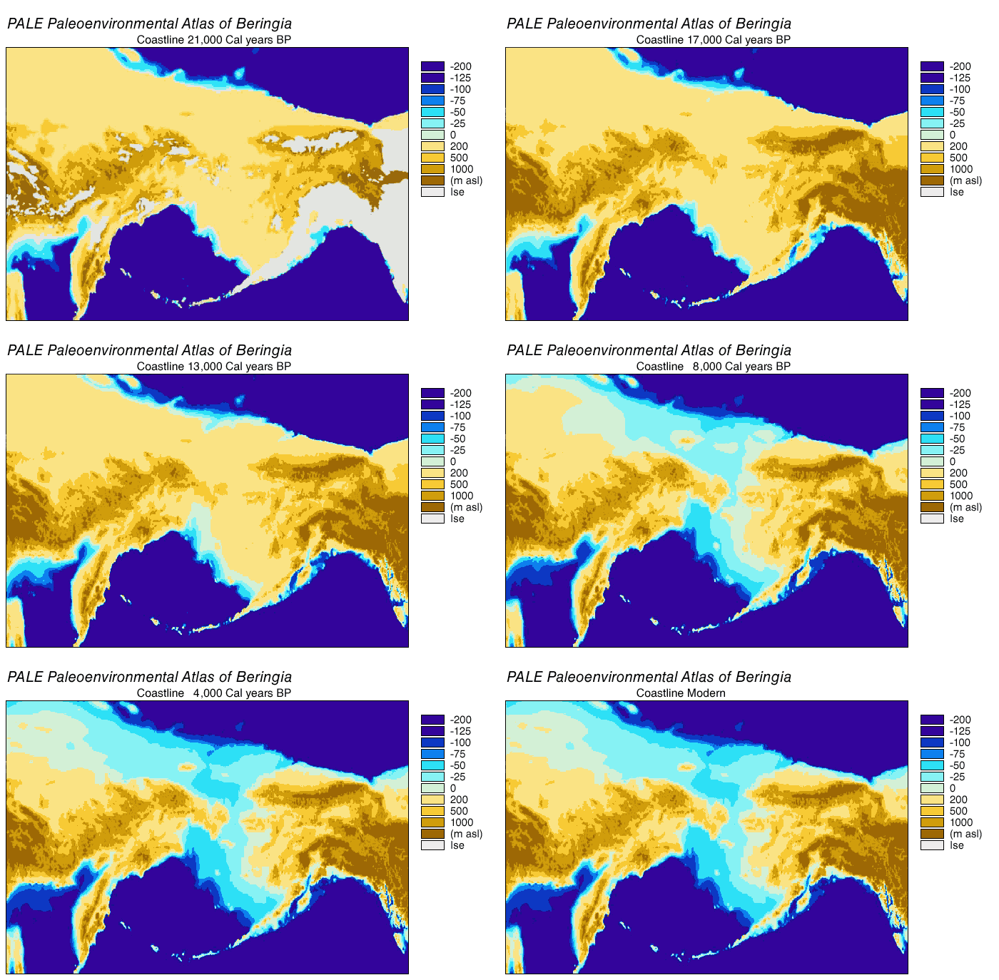
Doctoral student Lauriane Bourgeon's analysis of the bones, particularly a horse jawbone with cut marks on it, appears to confirm Cinq-Mars's original conclusion -- that human hunters were using the Bluefish Caves at least 24,000 years ago, at the height of the last glaciation. At that time sea levels were much lower than today, and people could have crossed to North America from Siberia on the wide, dry, windswept plains of Beringia, a route now blocked by the waters of the Bering Strait.
Beringia land bridge-noaagov

At the time Cinq-Mars published his first account of the excavation, the prevailing theory said humans arrived in North America from northeastern Siberia about 14,000 years ago at a time when the glaciers were finally disappearing, but when there was still a dry-land link between Asia and North America. They then followed an ice-free corridor between glaciers that led them south to the rest of the Americas. The problem with that theory is the growing body of evidence that no such corridor existed or was inhabitable at that time, as well as another growing body of evidence that people were living well south of the glaciated lands before the glaciers disappeared.

Cinq-Mars's find and Bourgeon's re-analysis of it support another theory: the Beringian standstill hypothesis. According to that theory, humans moved into the dry region linking Asia and North America 10,000 years or more before the great ice sheets melted and the sea level rose. And there they stayed, making a decent living from the animals -- both large and small -- that shared their giant refuge from the ice.

But what about those people living farther south when the ice was still melting? Current thinking suggests they might have arrived by sea, travelling down the west coast of North America, with its rich resources of shellfish and other coastal foods. A report just released dates a cache of artifacts found in Idaho to 16,000 years ago. A joint research effort by Western scientists and First Nations in British Columbia recently found even more startling evidence to support the coastal theory -- 29 footprints left, probably, by a small family walking along a beach 13,000 years ago.

Unravelling the mystery of humans in the Americas is no easy task. Much of the evidence was ground to dust by kilometres-deep ice or flooded by rising seas as the ice melted. But scientists and Indigenous peoples are working on it. It's still a can of worms, but each worm that emerges changes the picture slightly and makes it a little clearer. And a lot more interesting.

Claire Eamer's most recent book is Out of the Ice: How Climate Change is Revealing the Past (Kids Can Press, 2018).

2 Feb 2018

Exploring Haida Gwaii

Sci/Why's peripatetic correspondent Margriet Ruurs sends us another report from a fascinating part of the world - this time from Haida Gwaii, on the western edge of Canada. -CE

By Margriet Ruurs

Haida Gwaii – the very name conjures up images of windblown spruce clinging to rocks surrounded by foamy waves, not unlike an Emily Carr painting. The archipelago stretches along the northern BC coast almost to Alaska. You can reach it by ferry from Prince Rupert or fly in from Vancouver.

We flew into Sandspit, a tiny town on the northeast shore of huge Moresby Island. We wanted to visit the very southern tip, which is in a National Park called Gwaii Haanas. Basically, the only way to reach this remote region is by a Zodiac (inflatable boat) tour offered by a local wilderness company called Moresby Explorers. We studied our options, counted our coins and decided to splurge on a four-day trip with a photography theme.

Bryan, our guide and skipper, picked us up and also five other guests with whom we would spend the next four days on a Zodiac. We drove from Sandspit across a ridge of Moresby Island, on dirt logging roads, to Moresby Landing where we were outfitted with bibbed rain pants, large rain jackets and gumboots. We’d live in these for the next few days. We wore undershirts, a sweater, a fleece jacket topped by our own rain jackets and then the provided rain gear over top. This meant we could only wobble like astronauts in space suits.

Of course we had prepared ourselves for four days of driving rain, grey skies and grey waves. Fortunately, we were lucky and only ended up with a half day of rain and three-and-a-half days of blue sky and sun and/or cloudy but dry weather. Considering that Gwaii Haanas averages rain for about 230 days a year, we were lucky.


We had not even left the Landing when I spotted the first black bear browsing on the intertidal beach. The island’s bears have evolved to have much longer snouts than the mountain bears we are used to seeing on the mainland. Like the Galapagos, even the same species of animals have made adaptations to different local environments resulting in, among others, a different subspecies of stickleback fish in every lake. At least 39 distinct subspecies of plants and animals evolved in the archipelago, including seven mammals, three birds and fifteen species of the stickleback fish that are found nowhere else in the world.

We cruised across inlets and around Louise Island to spend the first night at Moresby Float Camp, a guest house anchored in a secluded fjord. The blue skies reflected in mirror-calm green waters. We docked and were welcomed by two young women who cooked for us, offering us tasty appetizers, tea, coffee and hot chocolate. They even had a fireplace, giving us much needed warmth to warm our chilled hands and feet. After a great dinner of bbq salmon, salad, veggies and rice we fell asleep in no time.

The next morning we bundled up again. This became a ritual: two or three layers of warm clothes, thick socks and gloves. Then our own outer gear, the provided rain pants tucked into the gumboots and the rainjacket over top of everything else. By the time you can’t bend down anymore, you still have to manoeuvre into a lifejacket and into the waiting Zodiac. We’d pull a warm hat and scarf over nose, mouth and face and then we were ready to zoom across Hecate Strait to our next destination.

On our way by Zodiac to the most southern tip of Gwaii Haanas, we visited ancient village sites and remnants of totem poles in several locations: Skedans, Tanu, S’qang Gwaii, Rose Harbour and more. Each site has its own intrigue and charm. Skedans is a village site with house remnants and totem poles, but not as many as in the most southern tip S’qang Gwaii. Here, a mystical and misty atmosphere enhances the site where old spirits dwell and history is tangible. The bleached and weathered totems lean against moss covered house beams. The beach still tells stories of canoe runs between rocks, where the “Vikings of the Pacific” showed their power by rowing their long boats far east, north and south, taking slaves as they encountered other nations.

I was intrigued to learn that a Haida Chief could marry a slave woman, thus making the former slave the most powerful matriarch of the clan. In this matriarchal society, men do as the leading woman dictates and children are part of their mother’s lineage.

I also learned about different totem poles: the shortest one were usually house poles, depicting the family’s clan and history. Tall plain poles with rings are potlatch poles, showing how many potlatches, or celebrations, have been held. Some poles are a memorial for a particular person, sharing his life story, while yet others have a hollowed-out square opening at the top housing a bentwood box of bones: a burial pole. Their silent stories are impressive and pay tribute to a society that lived here long before “contact” – as the period after the arrival of European explorers’ ships is called.

Houses were large, sometimes dug down to allow more space. Immense ceiling beams were held up by corner posts and closed by cedar walls. Now, all that remains is rounded beams covered in soft green moss, often with a new cedar tree growing on each corner as the trees reseeded. Slowly and silently, history is swallowed up by the rainforest. The Haida people have chosen to let their history return to the earth, as it always has, rather than have Parks Canada follow their usual mandate of preserving history.

We were most impressed by the Watchmen. This ancient term refers to Haida who spend the summer in each historic location. They are provided with a small house with a wood stove and basic comforts. Here they work for the summer, hosting visitors. They are extremely well spoken, gracious hosts with a wealth of knowledge about their people. Each host told us amazing stories. Haida Gwaii is made up of stories and the oral history seems alive and well. We heard stories of how people first came to populate the earth when Raven found a clamshell full of little people on Rose Spit. He pried open the shell and the people spilled out. Raven also brought light to the world.

Bear married a woman who gave birth to bear cubs, and in return he gave hunting powers to humans. There are many tales of supernatural beings in this land. Mostly, these are people wearing animal cloaks. Eagle, Raven, Whale, Bear – they all have specific powers and fascinating stories. Haida also strongly believe in reincarnation.

One of the men who told stories, told us of the impressive oral history. “When I was about 10 years old,” he said, “my uncle called me into his house and told me a two-hour story. The next night I had to come back and tell the story back to him without embellishing, best as I could.”

This repeated night after night until he had memorized much of his own history. The tradition continues today as he tells his daughter the ancient tales and makes her tell them back to him.

We learned to chew spruce tips and licorice root. Even ate herring roe on kelp. We saw many, many eagles. A few glimpses of whales as well as two bears.

One overnight was spent in Rose Harbour, an old whaling station. Much debris, buildings and rusty tools remind one of an era when people caught and processed whales for oil. I found it a sad place to be. The lone woman who lives here offers a guest house and meals to Moresby Explorers. We ate greens from her immense garden and freshly caught ling cod. In the morning she ground grains on her converted exercise bike to make us pancakes with rhubarb sauce from the garden. An outhouse and wood-heated shower made it into a rustic adventure.

All photos by Margriet and Kees Ruurs.
12 Aug 2016

Life and Death in the Salish Sea

By Claire Eamer
An orca, or killer whale, in the Salish Sea near Nanaimo.
Alan Daley photo

My husband, Alan, and I live on a small island in the Salish Sea, the body of water that lies between Vancouver Island and mainland British Columbia. Our place is on a low cliff overlooking the sea, and we spend a lot of time watching what goes on out on the water. That's what Alan was doing one afternoon early in May this year when he spotted a pod of orcas (killer whales). Here's his description of what he saw.

Alan speaking now:

Whales mill about a sea lion, its flipper visible in the turmoil.
Alan Daley photo
I discovered orcas just below off the cliff. They were milling about, and I noticed there was a sea lion in their midst. It was just lying still in the water for the most part. 

The whales repeatedly passed close to it, sometimes passing under it and flinging it partly out of the water. 

A sea lion tries to grab a breath, as killer whales attack it.
Alan Daley photo
Occasionally, I saw the sea lion put its head up and take a breath of air, but when it showed any signs of life, the beating intensified. 

There were a total of six whales. Two large males mostly hung out upwind/seaward of the action, and slapped the water occasionally with their tails. The smaller whales did most of the work. 

They seemed to have a strategy of exhausting the sea lion through physical beating and preventing it from breathing by huge splashes that sent it underwater. 

The injured sea lion is tossed into the air again.
Alan Daley photo
After I had watched for more than an hour, they headed off north with the sea lion seemingly moving without making any swimming motions. A couple hours later, I saw the body drift back down past the cliff.

Alan contacted the Orca Network to report the sighting and  included a couple of his photographs.

Howard Garrett of the Orca Network showed the photos to an expert, Dave Ellifrit of the Center for Whale Research. He identified the two large males as T19B and T19C, members of a pod of Bigg's killer whales -- also called transient killer whales.

Bigg's killer whales live in small family groups led by a female. They prey mainly on sea mammals, hunting up and down the coast of northwestern North America.

The kind of behaviour Alan watched might have been hunting lessons for young members of the pod or simply hunting practice. Steller sea lions are roughly the size of a bear and have formidable teeth and claws, so buffetting them with waves and tail-swipes keeps the whales safely away from the sharp bits.
Whales circle the sea lion, now seriously injured or dead. Alan Daley photo
The Salish Sea is also home to resident pods of killer whales. The resident whales live very different lives -- eating fish, mainly salmon, rather than sea mammals. They have different behaviour patterns, different dialects, and different cultures, and the two killer whale cultures seem to have very little contact with each other.

There's a wealth of information about both resident and Bigg's killer whales on the Orca Network website. And if you happen to be near the Salish Sea and spot some killer whales, let the network know. Every bit of information helps us understand and protect these amazing animals.

17 Oct 2014

Soapberries

By Shar Levine

As part of the research for my new book, I happened to virtually meet Dr. Nancy Turner, a world-renowned ethnobotanist who teaches at the University of Victoria. Dr. Turner literally wrote the book on the Ethnobotany of the Aboriginal Peoples of British Columbia.

If you were ever lost in the woods in B.C. or stuck on a deserted island in the Pacific Northwest, you would want Dr. Turner by your side. She would be able to find enough foraged foods to keep you fed until help arrived. Not only would she be able to identify non-poisonous mushrooms for a meal, but she could also prepare a unique dessert --- soapberry whip, known by some as Indian Ice Cream.

Despite its common name, the treat does not contain cream, and it is not frozen. The dish is made using soapberries, a plant in the oleaster family. The soapberry or soopalallie (Shepherdia canadensis) is not like your usual blueberry, strawberry or raspberry. According to Turner, “It has a distinctive bitter flavour due to the presence of low levels of saponins.” Saponins are natural detergents. As a result, when the juice of the berry is whipped, it will foam, so it looks like beaten egg whites or whipped cream with an orangey-pink tinge.

Soapberries can be difficult to pick or harvest, and the best way to gather the fruit is to “beat around the bush.” No, really, put a cloth below the plant and tap the branches sharply. The ripe berries will fall off the branches and onto the cloth.

Once you have gathered about ¼ cup of ripe berries, put them in a very clean bowl. If there is any grease in the bowl, the berries will not whip. Crush the berries and then add cold water, at little at a time, beating the liquid with an old-fashioned rotary whisk or electric mixer until it is stiff and forms peaks. You will probably need about a cup (250 mL) of water, added slowly, to make a bowl of soapberry whip. The dessert will be quite tart, and Dr. Turner recommends using apple juice instead of water, or adding in sugar or other sweeteners after the mixture starts to stiffen.

Turner says, “Don’t be confused by the name. There is another dish that some people call ‘Eskimo’ ice cream made by warming fat then whipping it by hand with snow and berries as it cools into a soft mixture.” 

If you would like to try to make this treat, look for a shrub that is about 1-2 metres (3-6 feet) tall, with a grayish bark and small, oval, green leaves. The berries are found in clusters and will be orange or reddish and translucent when ripe. The leaves and stems are covered with brown scales. Male and female flowers grow on different bushes, so only the female bushes will produce berries. The plant grows in many places across Canada, but does not flourish in really wet areas. Before picking this fruit, make sure it is a soapberry and not any other berry that might be harmful.

This versatile berry is high in vitamin C and has been used by indigenous people to treat high blood pressure, flu and tuberculosis. Smearing the berries on acne and other skin conditions, as well as using the fruit as a skin cleanser, are among the other uses for soapberries. The roots, stems and bark of the plant were also used for other medicinal purposes.

Berries can be preserved using traditional jam recipes, or made into a puree to be used in drinks. They can also be dried and made into cakes for use in recipes throughout the year. If you are interested, here is a paper by Dr. Turner and Carla M. Burton, called “Soapberry: Unique Northwestern Foaming Fruit.”


4 Apr 2014

William Wallace Gibson and the first Canadian-built airplane

By Claire Eamer

On February 23, 1909, John McCurdy made the first powered flight in Canada, flying the Silver Dart at Alexander Graham Bell's home in Baddeck, Nova Scotia. The Silver Dart was designed by McCurdy and built in the United States, where Bell and his associates had been working on powered flight. So - while it was the first powered flight in Canada - the Silver Dart wasn't the first Canadian-built powered airplane.

A full-scale replica of the Gibson Twin-plane at the BC Aviation Museum.
That honour belongs to a peculiar-looking, kite-like airplane designed, built, and flown by Victoria flight enthusiast William Wallace Gibson just a year and a half after the Silver Dart's flight. Gibson, a former farmer and businessman from the Regina area, had been quietly experimenting with kites and elastic-powered airplanes for several years. He had also designed an air-cooled engine especially for his experimental plane and had it built in Victoria.

On September 8, 1910, Gibson powered up what he called the Gibson Twin-plane, rolled across a pasture near Victoria (now a school sports field), and lifted off the ground for less than eight metres. He had been nervous about whether the plane would work and afraid of being mocked, so he didn't tell anyone about the experiment. But it flew!

Gibson's engine drove two propellers, one at each end.
So Gibson invited witnesses and planned a second, formal flight. On September 24, 1910, he took off again. This time the plane flew 200 feet (just over 60 metres). The flight was a clear success, but it came to a bad end. A cross-wind pushed the plane towards an oak tree, and Gibson had to make a hasty landing. With no brakes and limited control, he rolled helplessly across the rough ground and straight into the tree. Gibson was thrown clear, but the plane was a wreck.

That didn't stop Gibson. He designed a new plane with multiple narrow wings and called it the Gibson Multi-plane. It was powered by the same engine he had designed for the Twin-plane. Then he went off in search of wide open spaces to test the new plane. He found his space in Calgary, and on August 12, 1911, he was ready.

The Multi-plane was piloted by his assistant, Alex Japp. It took off safely, reached an altitude of 100 feet (over 30 metres), and cruised for over a mile (about 1.7 kilometres) - just one of several successful flights it made that day. Unfortunately, the Gibson Multi-plane came to grief on landing, just as its predecessor had. A last hard landing on rough terrain was too much for it, and the plane broke up.
The pilot perched in the tiny seat below the arrow.

Gibson lived until 1965, long enough to see airplanes and air travel become a major industry, but that flight in Calgary was the end of his experiments with flight. However, it wasn't the end of his planes.

A full-scale replica of the Gibson Twin-plane dangles from the ceiling of the British Columbia Aviation Museum near Victoria. The original engine Gibson used in both planes is in the collection of the Canadian Aviation and Space Museum in Ottawa. And there's a model of the Twin-plane in the National Air Museum in Washington, D.C.

Here are a few links with more of Gibson's story:

http://victoriahistory.ca/blog/2010/08/the-gibson-twin-plane/

http://www.canadianflight.org/content/history-flight-bc-0

http://www.bcaviation.com/gibson.htm

All photos by Claire Eamer.

22 Dec 2012

Fuel Spills


Do science and outdoor sports go together for you? They do for me! I do a lot of thinking when out in my kayak. Sometimes the things I see when kayaking remind me of birdwatching and climate change science. But most recently, while out in my kayak I passed a floating plastic bag that might have blown off a boat, and a sunken tin pie pan that was probably frisbee-ed from shore. Seeing human trash reminded me of why I had to get to my computer and write this post. There have been a series of fuel spills locally, where I live in Saanich, part of Victoria.
You can read about one of the first recent spills in the Saanich News in their article appropriately titled "Oil spill stains urban miracle." It's on the front page, with a sub-heading "Catastrophe strikes Coho-laden creek." I hadn't thought of an urban creek being the subject of study for working biologists, but it is. And there are school visits to the creek as well, so that students can learn about Nature in their own home neighbourhood.
My friend John Herbert took this photo of Colquitz Creek. That's the salmon stream that we've written about here, the one that runs from Beaver Lake through Panama Flats to Portage Inlet.
This spill was from a home heating oil tank that leaked. It happened when a fuel delivery was made to the wrong address, and the wrong home's unused tank was filled with home heating oil. A pipe leading from the fuel tank sprung a leak, and over a few days released an estimated 1,000 litres of heating oil into Swan Creek, which drains into Colquitz Creek. Once the oily sheen on the stream was pointed out to Saanich municipal workers, they traced the fuel up to the source of the leak. Other leaks have since been traced back to other tanks.


These fuel tanks weren't mine or in my own neighbourhood, but I must have walked within a hundred yards of them several times before eating and relaxing at a nearby home of friends or family. That's it, for me. Not in my back yard. Not in my friends' and families' back yards. Accidents happen, but fuel tanks are owned by people who can look after them. No excuses. When I walked back from the beach, I put the kayak away and looked at my landlady's fuel tank. No visible leaks. Not in my yard.
I'm no fuel-servicing expert. I'm not a marine biologist, or a fresh-water biologist either, but I do get out on the water often in my kayak. Every small boat user interacts hands-on with the water in a personal way. We can understand the effects of fuel spills on waterways, effects that some people don't easily understand because they don't see the plants and animals like we do. Now I'm trying to put that understanding to use.
Another recent spill of home heating fuel into the watershed in Greater Victoria can be read about here at the Times-Colonist newspaper website. The Times-Colonist article noted that:
A fact sheet from the provincial Environment Ministry says homeowners are potentially liable for cleanup costs whether they are aware of the existence of an oil tank or not.
Scary thought, eh? And home insurance doesn't cover fuel spills. One of the recent cleanups cost the homeowners $35,000.
Apparently, an old fuel tank can go from "looks ok" to "leaking" pretty darned fast... even when it's been checked by an expert from the fuel oil company. As one homeowner with an unexpected leak said to the Saanich News:
We had a platinum protection plan where (our oil company) would do sonic testing of the tank to check the thickness of the walls. We were also using their oil that’s supposed to have additives in it that retards corrosion,” Keith says. “We were sort of relying on that plan, to some extent, to give us a head’s up if something was up. At the end of the day that didn’t help us out. We’re kicking ourselves now – it was an old tank, why didn’t we just replace it? For $2,000 we could’ve avoided a ton of grief.”

It seems that tank leaks can happen suddenly and aren't as obvious as the crack along the coaming in my second-hand Pamlico kayak from Wilderness Systems.
So I will remember the statements by experts in the local newspapers: twenty-year-old fuel tanks can and do fail suddenly. I don't have to be a fuel expert to help my landlady make a proper plan for the fuel tank at her house! That's practical science we can put to good use. With planning, this home heating system will never be the cause for an expensive and environmentally damaging spill.
We can't stop all the fuel spills in the world, but we can each look after our own equipment. And if you see any fuel spilled on the ground or water in BC, in town or out in the boonies, call the 24-Hour Spill Line toll-free at 1-800-663-3456.


23 Nov 2012

Clues in the Rocks

By Claire Eamer

“The role of a geologist is much like the role of a crime scene investigator,” says Joel Cubley, geology instructor at Yukon College in Whitehorse. Geologists try to figure out what happened long ago in Earth’s history from small, fragmentary clues, he explains. But what took place long ago was certainly not small.

Cubley’s specialty is tectonics, and that’s just about as big as it gets. It’s the study of the movements of the great plates that carry the continents slowly over the face of Earth, pushing up mountains and excavating oceans as they go.
Out there, beyond the east coast of Newfoundland,
the Atlantic Ocean is slowly getting wider.
Claire Eamer photo

Tectonics is a relatively new field. About a century ago, German scientist Alfred Wegener suggested that the continents move, but most geologists thought he was talking nonsense. It wasn’t until well into the 1950s that American scientists using sound waves to map the ocean floors found proof of Wegener’s theory. Marie Tharp, one of the few women working in geology at the time, spotted what looked like a rift valley on the floor of the North Atlantic Ocean. It turned out to be exactly that — a place where two parts of Earth’s crust are pulling apart, widening the ocean and pushing Europe and North America away from each other about as quickly as your fingernail grows.

Even that slow movement, over time, can create huge changes. On the west side of North America, tectonic movement has thrown up range after range of mountains between the eastern slopes of the Rockies and the Pacific Coast. Cubley is particularly interested in gap between a couple of those ranges, a place where two sections of crust have moved in a way that stretches the surface rock. It’s a 200-kilometre-wide zone of jumbled ridges and valleys called the Grand Forks Complex, lying roughly between Castlegar and Revelstoke in southern British Columbia and extending down into Washington State.
The snow-capped St. Elias Mountains, the highest
in Canada, were created by slow tectonic movement.
Claire Eamer photo

A feature of the Grand Forks Complex is occasional outcrops of metamorphic rocks, hundreds of millions of years older than the surrounding rock. How did they get there? That, in simple terms, was the subject of Cubley’s doctoral research.

“Metamorphic rocks are just rocks that have been cooked,” he says. Where Earth’s crust is pulling apart strongly enough to create a crack or fault, super-hot “cooked” rock can well up from far below the surface. Cubley suspected that the metamorphic rock in the Grand Forks Complex was evidence of a fault. But where?

In places like the Great Rift Valley in Africa, the fault is obvious – and huge. But the fault associated with the metamorphic rocks of the Grand Forks Complex would be much smaller and harder to spot. Cubley tackled the problem in the traditional geologist’s way, by sampling and mapping rocks on foot.

He spent several summers bushwhacking across the rough, wild landscape of south-central British Columbia, camping, hauling gear, and swatting bugs. When he finally found the fault, it was a bit of a let-down.

“It was a shallow ravine full of scrubby trees,” says Cubley. “That was kind of soul-destroying!”

But not for long. Cubley’s soul bounced back, and he’s well on his way to understanding how that modest ravine is linked to the unusual rocks of the Grand Forks Complex.

What he knows at this point is that the metamorphic rocks were formed at a depth of about 20 kilometres and a temperature of about 750 degrees C. Roughly 50 million years ago (almost yesterday in geologic terms), they welled all the way up to the surface and then cooled very quickly.

“I still can’t explain how they got to the surface that quickly,” Cubley says. But, with the help of a great deal of modern technology (and some more bushwhacking), he’s working on it.

5 Jul 2012

Paddling the Ice Kap

No, I didn't get up North or to Antarctica, to paddle my kayak at either of the actual ice caps. Instead I got to try out a kayak model called the Ice Kap, from Sterling Kayaks. It was a great day to learn more about kayaking science. Yes, there's science in kayaking! There are all the measurements, when designing and constructing boats. There's also research. Which boat shape is good for racing, or for surfing in waves? And then there are the experiments. No lab coats and clipboards for me -- I just try the different boats and have fun, while my friends Louise and John keep a notebook of their own experiments with kayaks.

At the MEC Paddlefest on Willows Beach, we found an assortment of several models from Sterling Kayaks. Each is a custom job, with the foot pedals set to accommodate the paddler's own leg length, for example. I got to sit in an Illusion, but even with the footpedals adjusted as far as possible, my feet still couldn't reach. That would be no problem if I owned one of their kayaks, explained the designer, Sterling Donaldson. He would put the footpedals closer to the seat for someone as short as me. He's calculated the centre of gravity and balance points for all his kayak designs.

Donaldson gets fibreglass under his fingernails and epoxy all over his hands, he complained at one point. But there's no substitute for the hands-on approach when customizing a kayak for someone with special needs.

The foam seats are a terrific support... lifting the knees a little and fitting around the butt. I'm guessing that my partner Bernie would find THIS seat doesn't hurt his back. The seat back is good support, but low so that a paddler can lean back when rolling the kayak. On each side of the seat is a support for foam padding, to customize the fit to the paddler's thighs.

I got into the Ice Kap which is designed for small people. The coaming, the edge around the cockpit opening, is low. As in half-way up my thighs when I'm seated in the kayak. No more rubbing my elbows on the coaming with each stroke! That happens in most kayaks for me. The designer Donaldson pointed out, most shorter people are not only short in the leg, but have short backs as well. It's hard to roll a kayak that is too big.


My friend John Herbert  took a photo of me on the water in the Ice Kap. It's pretty clear in the photo that this boat has a lot of rocker, a curve which brings the keel up in the bow and stern. That makes for a lot of fun riding waves. I expressed some concern about the front deck being so high out of the water, and the stern so high. Wouldn't they catch wind and turn like a weather vane? "None of our boats weathercocks," Donaldson insisted.
The Illusion has a similar hull to the Ice Kap, but the coaming rises a little higher at the paddler's thighs and sides. John could tell that he wouldn't fit either model. At 6'4", he went for their Grand Illusion that fits the 6'3" designer. But the model on the beach had been padded to fit a thinner paddler. Not for John today!
Louise tried the Ice Kap as well, just to add another model to her research for which style of boat she would buy this summer. We compared notes. Afterwards, John and Louise changed out of their paddling clothes while I just wandered around evaporating. One of the most important things I learned about kayaking science is to wear clothes that evaporate dry quickly.
Our verdict: if you're a thin, short man or woman who is wanting an exciting kayak, try the Ice Kap for an experiment of your own. If you're not thin, try the Illusion as the coaming is just a little higher instead of pressing on the sides of your thighs.
And if you're a differently-able paddler (like every member of our paddling group, and plenty members of SISKA and VCKC and the entire crew of the Breaststokers Dragon Boat team), talk to a kayak designer about kayak science. How can a kayak meet your needs?
This particular designer understands. Sterling Donaldson not only talks the talk, he walks the walk with one leg and crutches on the beach among his kayaks. He grew up designing experimental aircraft with his father, and now he applies the scientific methods he learned to building kayaks.

23 Aug 2011

Very, Very Fishy

Posted by Vivien Bowers

In late September, I’m off to the salmon spawning creeks along the west coast of Haida Gwaii (Queen Charlotte Islands). For the third year in a row, I get to tag along with a fish biologist who is walking the streams to count the returning fish.

F-words
Fishy. Fecund. Fetid. The first time I walked these salmon spawning creeks I dredged up vocabulary I’d never used before. The moist air stinks of rotting fish, bear musk, bird droppings and compost. Hundreds of eviscerated salmon carcasses (which must also be counted) litter the banks. The bears sometimes just tear out the rich fish brains, leaving the rest to scavengers. Crows peck out the eyes, before the eagles chase them off. I’ve seen seagulls so glutted on fish they can hardly take off.

One little, two little, three little salmon...
I scramble after my biologist friend as he makes his way up the creek, eyes alert to shifting underwater shapes and shadows. He tosses a leaf onto the surface of a deep pool, and fish boil to the surface. In amongst the bigger chum there are fleeting dark silhouettes of coho. He uses his little hand-held clicker to record the count.

The rocks in the creek are slippery and scummy. Some of these watersheds have never been logged and we clamber over an obstacle course of moss-covered giant spruce deadfalls. Wading from one bank to another through tannin-brown water, I feel salmon bumping up against my legs.

Do-si-do with Bear
Bears and salmon go together. A researcher on Haida Gwaii found that a single bear will take about 1600 kilograms of salmon from a creek in one season. It will eat only about one half of what it catches; much of the rest decomposes on the forest floor. That’s how bears transfer massive amounts of nutrients from the ocean to the land. They are handy that way.

I appreciate the bears’ important niche in this ecosystem, but it’s a bit unnerving how many of them we meet. Haida Gwaii bears are particularly big. Last year I was on my own, counting fish in a tributary stream, when I came across a large bear scooping fish out of the water. I stomped on a dead branch, hoping to sound like a REALLY BIG bear and scare him off. Instead, the bear was curious and headed towards my noise. Quickly changing strategies, I stood up with a loud, “Hey bear!” He looked startled and fled. I continued upstream, following the salmon's journey deep into the primeval forest.

Vivien Bowers is the author of Wow Canada!, Crime Scene and other books for children. The cartoon panels are from "Swimming Upstream," an episode of the 'WebVoyagers' co
mic strip, written by Bowers and illustrated by Mike Cope, that appears in each issue of The Canadian Reader, published by LesPlan Educational Services Ltd. Vivien Bowers lives in Nelson, BC.